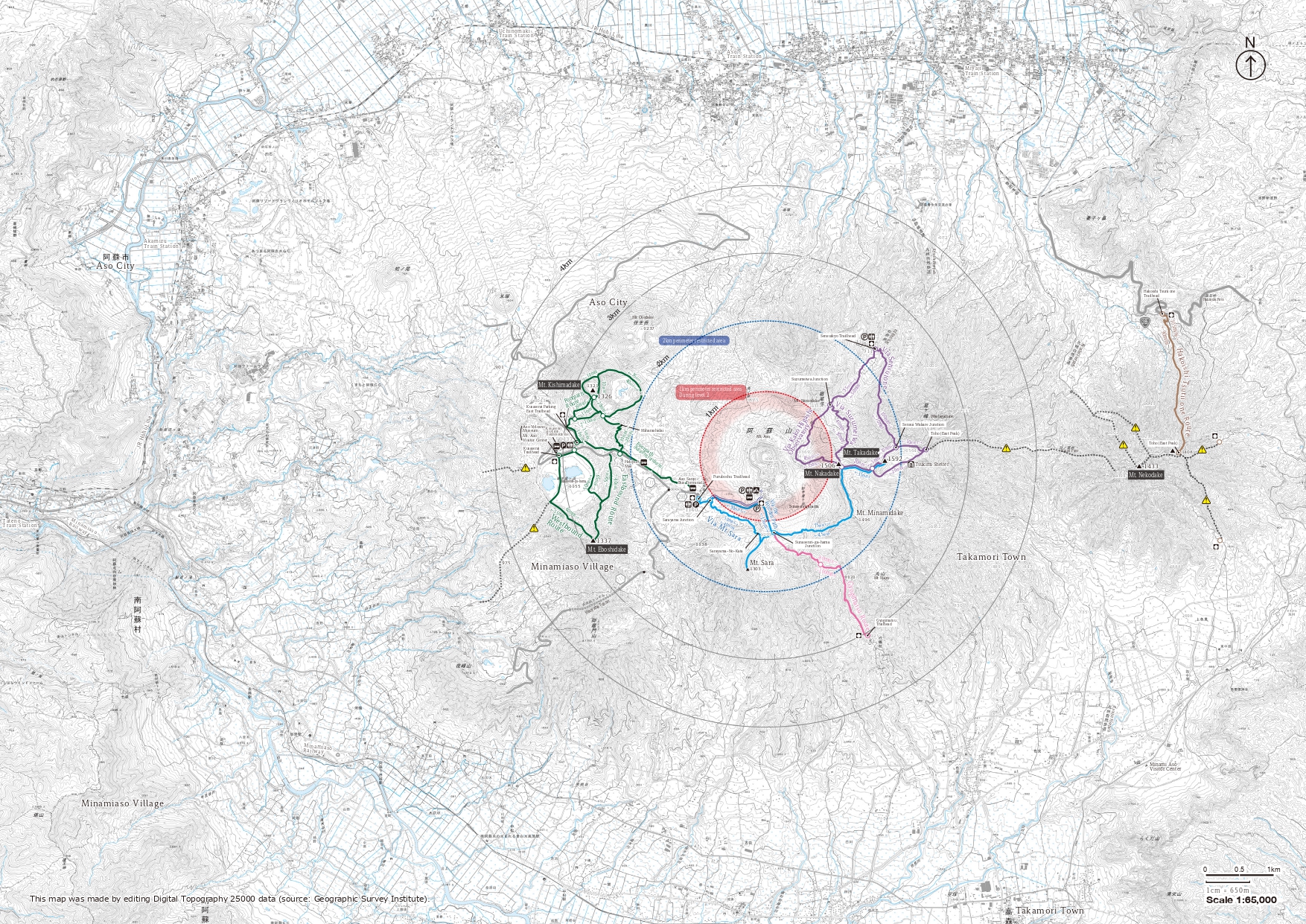
Aso-Kuju National Park (Aso Region) Aso Five Peaks Hiking Information
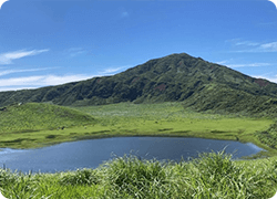
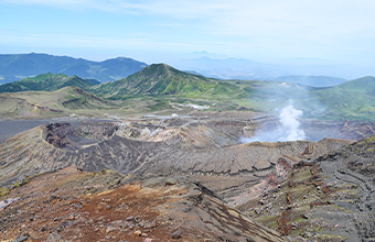
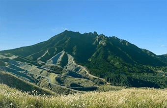
Aso Five Peaks comprises Mt. Takadake (1,592 m), Mt. Nakadake (1,506 m), Mt. Nekodake (1,433 m), Mt. Eboshidake (1,337 m), and Mt. Kishimadake (1,326 m). Each mountain has a distinct character. Mt. Takadake is the tallest of the five, providing hikers with a challenging but rewarding hike. Mt. Nakadake is Japan’s largest active volcano, and smoke can often be seen billowing from its summit. Mt. Nekodake is famous for its rugged ridges. Of the two smaller mountains, Mt. Eboshidake is characterized by the expansive Kusasenri-ga-hama Grassland located in the mountain’s saddle, and at Mt. Kishimadake, hikers can enjoy walking around the rim of a volcanic crater.
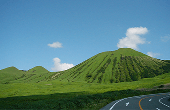
One of the biggest attractions of Aso Five Peaks is the contrast between its idyllic grasslands and looming, smoke-belching volcano, which never fails to leave a lasting impression on visitors to Aso-Kuju National Park.
Viewed from afar, these five peaks are thought to resemble the Buddha lying on his side and looking up toward the heavens. From this, the five peaks are also called “the Reclining Buddha of Aso.”
Click here for information about the various hiking trails at Mt. Aso.
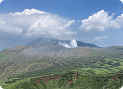
- Mt. Aso (Mt. Nakadake) is an active volcano that erupts regularly. Please check the Japan Meteorological Agency's volcanic activity page for the latest information on Mt. Aso's volcanic activity/volcanic alert levels.
-
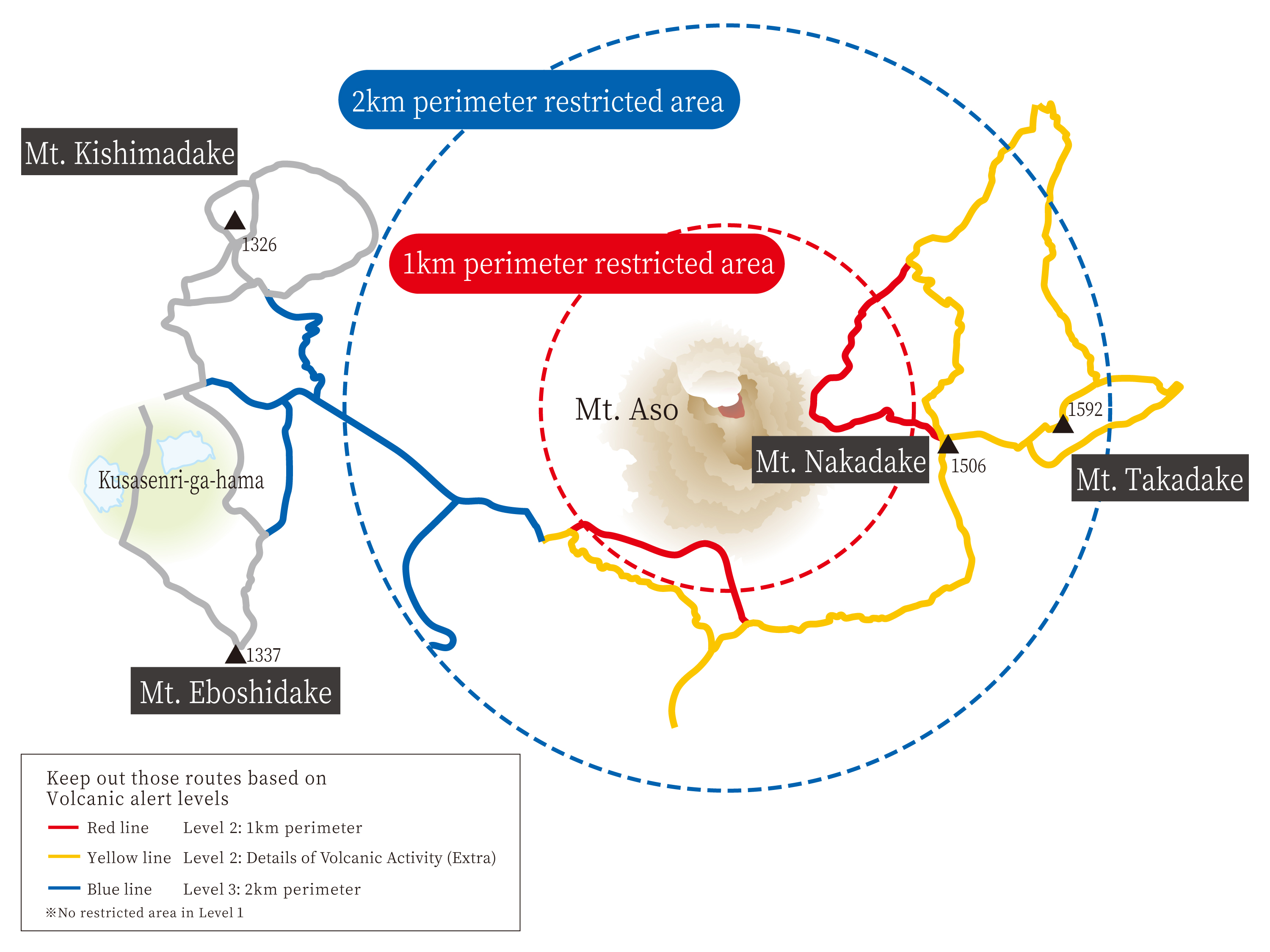
Some routes may be closed depending on the volcanic alert level.
Please check the Kumamoto Prefecture “Mt. Aso Mountain Climbing Information” page (Japanese only) for the most up-to-date information on currently open routes (displayed on a map).
Volcanic Alert Levels and Restriction Zones
About Volcanic Gas
Volcanic craters emit gases that are a potential health hazard. Please abide by the following rules to ensure your safety when visiting.
- IMPORTANT Volcanic gases can aggravate preexisting health conditions and pose a health hazard even at lower concentrations. Please do not climb Mt. Aso if you are pregnant, have asthma or other respiratory conditions, heart conditions, or are otherwise unwell. Do not climb Mt. Aso with infants or young children.
- Before starting your hike, please check the weather conditions and direction of the wind to determine where the volcanic gases will blow.· Be especially cautious on calm, sunny days, as the lack of wind makes it difficult for volcanic gases to dissipate, leading to higher concentrations.
- If you smell gas, please cover your nose and mouth with a damp cloth. If you begin to feel unwell, move away immediately.· Volcanic gases have a higher density than air, meaning that they tend to sink and gather in low-lying areas. Avoid valleys and keep to ridge lines and higher areas during your hike.
- Please bring a helmet and goggles to protect yourself from falling rocks and volcanic ash.
More information about volcano safety is available on the Mt. Aso Crater Regulation Information site (Japanese only).
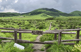
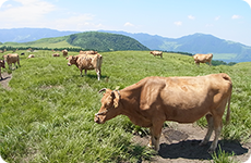
- The grasslands at Mt. Aso are bokuya (private grassland) and have been used as grazing and pasturage for hundreds of years. Although the bokuya are generally off-limits to hikers, some of the trails at Mt. Aso pass through these pastures. When hiking these trails, please stay on the path and do not disturb the grasslands.
- Animals may be grazing in the pastures during your hike. If you encounter any animals, please keep your distance and allow them to pass. Unauthorized contact with the animals or grasslands may damage vegetation or unknowingly introduce harmful pathogens, such as foot-and-mouth disease (FMD; Aphthovirus).
-
There are no camping sites or mountain huts on any of the trails; camping and
pitching tents is strictly prohibited.
· Exceptions apply only in an emergency situation, such as a sudden storm.
· There is an emergency shelter (Tsukimi Shelter) on Mt. Takadake’s East Peak. -
Under the Natural Parks Act, campfires are strictly prohibited in Special
Protection Zones. However, the use of a gas burner (for heating food, etc.) is
permitted.
· Please use gas burners responsibly and avoid using them near dry, fallen leaves or during drought periods.
-
Dial 110 or 119 for emergency services if you become lost, injured, or are
otherwise in need of emergency assistance.
· Use a whistle or airhorn to signal emergency services and make other hikers aware of your position.
· Emergency Aid is provided by the Aso Fire Department and Kumamoto Prefectural Police Mountain Rescue Team
-
We ask that all visitors fill out and submit a registration form prior to
beginning their hike. This form enables rescue teams to respond quickly in the
event of an emergency.
Planning your hike reduces the risk of getting caught unprepared and is essential for swift search and rescue. Registration forms can be submitted both digitally and on paper, so please choose the method that is most convenient.
· Mountain-climber registration forms are available at each trailhead next to a collection box. Once you have filled out the form, please deposit it into the box.
· Alternatively, a digital registration form can be submitted via the smartphone app “YAMAP.”
· The registration form itself can be downloaded from here (Japanese only).
· The form can also be submitted online via the Kumamoto Prefectural Police website (Japanese only).
-
None of the trails listed here have water refill or restroom facilities.
· Please use the restroom at the trailhead before beginning your hike, and/or carry a portable toilet.
· We recommend bringing a tent or poncho to create privacy when using the portable toilet.
Mt. Kishimadake
Mt. Kishimadake Summit Walking Trail
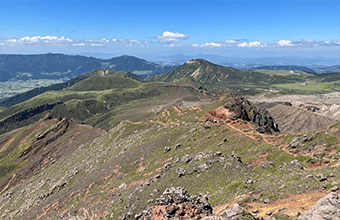
With maintained paths through grasslands, this beginner-friendly route is perfect for families and those seeking a pleasant walk. From the summit of Mt. Kishimadake (1,326 m), visitors can enjoy sweeping views of Mt. Takadake, Mt. Nakadake, and several volcanic craters.
Trail Data
| Time Required | Ascent: 35 mins. Descent: 25 mins. |
|---|---|
| Trailhead | Kusasenri Parking Lot East Trailhead |
| Trailhead Elevation | 1,137 m |
| Summit Elevation | 1,326 m |
| Incline, Terrain, and Trail Conditions | · Midmountain: winding, paved paths · Upper stretch: small, cutout steps · Summit: Unbroken path around the rim |
Access
| To the Trailhead | Public transportation: Bus (Kyushu Sanko): JR Aso Station → Aso Volcano Museum Car (incl. coach buses): Via Kusasenri Parking Lot |
|---|---|
| Parking | Kusasenri Parking Lot Fee: Passenger cars: 500 yen; 225 spaces For oversized vehicles, etc.: check at parking lot |
What to Bring
| Basic Equipment | Please see this page for details on equipment and hiking preparation. |
|---|---|
| Trail-Specific Equipment | Hiking boots are recommended for all trails, but sneakers or tennis shoes can be worn if staying only on serviced roads. |
Nearby Facilities
| Facilities on the Mountain | · Shops: 6 (incl. restaurants) · Bus stop (Kyushu Sanko) · Mt. Aso Visitor Center * Open 9:00 a.m. to 5:00 p.m.; information desk available on weekends and holidays * Check with each facility for the latest updates. |
|---|---|
| Public Restrooms | Kusasenri Restroom (running water, western-style toilets) |
Mt. Kishimadake
Kusasenri Grassland-Furubochu Walking Trail
This is a beginner-friendly route that visitors of all ages can enjoy. This trail runs between Furubochu Parking Lot and Kusasenri Grassland and provides ample opportunity to enjoy the idyllic Kusasenri Grassland scenery. It also offers views of volcanic smoke rising from Mt. Nakadake's crater.
Trail Data
| Time Required | Ascent: 45 mins. Descent: 45 mins. |
|---|---|
| Trailheads |
|
| Trailhead Elevation | Kusasenri Parking Lot East Trailhead: 1,137 m Furubochu Trailhead: 1,140 m |
| Incline, Terrain, and Trail Conditions | · A relatively flat, paved road with gentle slopes · Can also be hiked in snowy conditions with snow boots |
Access
| To the Trailhead | Public transportation:
|
|---|---|
| Parking |
Kusasenri Parking Lot Fee
· Passenger cars: 500 yen; 225 spaces Furubochu Parking Lot Fee
· Passenger cars: 500 yen; 195 spaces Sunasenri-ga-hama Parking Lot Fee |
What to Bring
| Basic Equipment | Please see this page for details on equipment and hiking preparations. |
|---|---|
| Trail-Specific Equipment | Sneakers are acceptable footwear |
Nearby Facilities
| Facilities on the Mountain |
Kusasenri Parking Lot Furubochu Parking Lot (formerly: Aso Sanjo Parking Lot) Sunasenri-ga-hama Parking Lot * Check with each facility for the latest updates. |
|---|---|
| Public Restrooms | Kusasenri Restroom (running water, western-style toilets) Furubochu Parking Lot Restroom |
Mt. Eboshidake
Westbound Loop/Eastbound Loop
The summit of Mt. Eboshidake provides hikers with
spectacular views of the Kusasenri Grassland, the southern side of the somma volcano,
and Mt. Nakadake. On clear days, it is possible to see as far as Mt. Unzen or the
Ariake Sea.
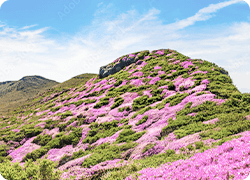
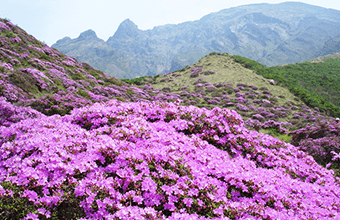
Mt. Aso’s natural scenery offers visitors unique experiences regardless of season. The
blooming Kyushu azaleas (Rhododendron kiusianum) at the end of May is
particularly noteworthy, as they color the mountainside in varying hues of pink and
purple.
Trail Data
| Time Required (Westbound Loop) | Ascent: 60 mins. Descent: 55 mins. |
|---|---|
| Time Required (Eastbound Loop) | Ascent: 65 mins. Descent: 50 mins. |
| Trailhead | Kusasenri Trailhead |
| Trailhead Elevation | 1,137 m |
| Summit Elevation | 1,337 m |
| Incline, Terrain, and Trail Conditions | · Flat grasslands at Kusasenri · Moderately steep dirt path from the start of the climb to the summit |
Access
| To the Trailhead | Public transportation: Bus (Kyushu Sanko): JR Aso Station → Aso Volcano Museum Car (incl. coach buses): Kusasenri Parking Lot |
|---|---|
| Parking | Kusasenri Parking Lot Fee: Passenger cars: 500 yen; 225 spaces Oversized vehicles: check at parking lot |
What to Bring
| Basic Equipment | Please see this page for details on equipment and hiking preparations. |
|---|---|
| Trail-Specific Equipment | Footwear: hiking boots (low-cut OK) Other basic hiking equipment |
Nearby Facilities
| Facilities on the Mountain | · Shops: 6 (incl. restaurants) · Bus stop (Kyushu Sanko) · Mt. Aso Visitor Center * Open 9:00 a.m. to 5:00 p.m.; information desk available on weekends and holidays * Check with each facility for the latest updates. |
|---|---|
| Public Restrooms | Kusasenri Restroom (running water, western-style toilets) |
Mt. Takadake & Mt. Nakadake
Sunasenri Trail
(Boardwalk/Mt. Sara Routes)
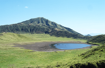
The volcanic ash covering the Sunasenri Plains gives them an otherworldly quality, like the barren surface of the Moon. From its desolate mountain terrain and rising smoke to the emerald-green crater lakes (hot spring pools), Mt. Nakadake gives visitors a glimpse into the inner workings of planet Earth. Please be sure to check the latest information on the volcanic activity at Mt. Nakadake.
Trail Data
| Time Required (Boardwalk Route) | Ascent Mt. Nakadake: 125 mins. Mt. Takadake: 150 mins. (25 mins. from Mt. Nakadake) Descent Mt. Nakadake: 95 mins. Mt. Takadake: 115 mins. (20 mins. from Mt. Nakadake) |
|---|---|
| Time Required (Mt. Sara Route) | Ascent Mt. Nakadake: 130 mins. Mt. Takadake: 155 mins. (25 mins. from Mt. Nakadake) Descent Mt. Nakadake: 90 mins. Mt. Takadake: 110 mins. (20 mins. from Mt. Nakadake) |
| Trailhead | Furubochu Trailhead |
| Trailhead Elevation | 1,140 m |
| Summit Elevation | Mt. Takadake: 1,592 m Mt. Nakadake: 1,506 m |
| Incline, Terrain, and Trail Conditions (Boardwalk Route) |
· Until Sunasenri-ga-hama junction: paved roads and boardwalks · Past the junction: rocky paths with volcanic ash · To Mt. Nakadake, Mt. Takadake: relatively flat ridge · To Mt. Minamidake: steep incline · It is possible to traverse the rim of Mt. Takadake as far as the East Peak |
| Incline, Terrain, and Trail Conditions (Mt. Sara Route) |
· Until Mt. Sara detour junction: paved path along road · Until the Sunasenri-ga-hama junction: uneven dirt path with volcanic ash |
Access
| To the Trailhead | Public transportation: Bus (Kyushu Sanko): JR Aso Station → Aso Sanjo Terminal Car (incl. coach buses): Sanjo Parking Lot |
|---|---|
| Parking (Boardwalk Route) | Furubochu Parking Lot (formerly Aso Sanjo Parking Lot) Fee: · Passenger cars: 500 yen; 195 spaces · Oversized vehicles: check at parking lot Sunasenri-ga-hama Parking Lot Free (Mt. Aso Park Toll Road: 800 yen); 15 spaces * Please check Volcanic Alert Levels in advance, as the parking lot is located within the one-kilometer restriction zone. |
| Parking (Mt. Sara Route) | Furubochu Parking Lot (formerly Aso Sanjo Parking Lot) Fee: · Passenger cars: 500 yen; 195 spaces · Oversized vehicles: check at parking lot |
What to Bring
| Basic Equipment | Please see this page for details on equipment and hiking preparations. |
|---|---|
| Trail-Specific Equipment | Recommendations: · Footwear: hiking boots (mid-cut boots or higher) · Helmet, goggles, damp towel Other basic hiking equipment |
Nearby Facilities
| Facilities on the Mountain (Boardwalk Route) |
Furubochu Parking Lot (formerly Aso Sanjo Parking Lot) · Shops: 1 · Bus stop (Kyushu Sanko) Sunasenri-ga-hama Parking Lot None |
|---|---|
| Facilities on the Mountain (Mt. Sara Route) |
Furubochu Parking Lot (formerly Aso Sanjo Parking Lot) · Shops: 1 · Bus stop (Kyushu Sanko) * Check with each facility for the latest updates. |
| Public Restrooms | Furubochu Parking Lot Restroom |
Mt. Takadake & Mt. Nakadake
Sensuikyo Gorge Trail
(Crater East View Point/Suzume-iwa Rock/Sensui Ridge Routes)
This is one of the more challenging trails at Mt. Aso, taking hikers directly up the rocky ridge of Mt. Takadake (1,592 m). We recommend planning your visit around May, when clusters of Kyushu azaleas (Rhododendron kiusianum) bloom at the Sensuikyo Gorge trailhead and Mt. Takadake East Peak, coloring the foot of the mountain in hues of pink. Please be sure to check the latest information on the volcanic activity at Mt. Nakadake.
Trail Data
| Time Required (Crater East View Point Route) |
Ascent Mt. Nakadake: 95 mins. Mt. Takadake: 120 mins. (25 mins. from Mt. Nakadake) Descent Mt. Nakadake: 70 mins. Mt. Takadake: 90 mins. (20 mins. from Mt. Nakadake) |
|---|---|
| Time Required (Suzume-iwa Route) |
Ascent Mt. Nakadake: 90 mins. Mt. Takadake: 115 mins. (25 mins. from Mt. Nakadake) Descent Mt. Nakadake: 65 mins. Mt. Takadake: 85 mins. (20 mins. from Mt. Nakadake) |
| Time Required (Sensui Ridge Route) |
Ascent Mt. Nakadake: 110 mins. Mt. Takadake: 130 mins. (20 mins. from Mt. Nakadake) Descent Mt. Nakadake: 80 mins. Mt. Takadake: 105 mins. (25 mins. from Mt. Nakadake) |
| Trailhead | Sensuikyo Gorge Trailhead |
| Trailhead Elevation | 911 m |
| Summit Elevation | Mt. Takadake: 1,592 m Mt. Nakadake: 1,506 m |
| Incline, Terrain, and Trail Conditions (Crater East View Point Route) |
· Until Crater East View Point: relatively steep paved road · From Crater East View Point: mountain trail covered with volcanic ash · From Mt. Nakadake: the same as the Sunasenri Route |
| Incline, Terrain, and Trail Conditions (Suzume-iwa Route) |
· Until Suzume-iwa Rock junction: relatively steep paved road · From Suzume-iwa Rock junction to Mt. Nakadake: rocky path with intermittent sharp inclines and one section with fixed ropes · From Mt. Nakadake: the same as the Sunasenri route |
| Incline, Terrain, and Trail Conditions (Sensui Ridge Route) |
· Past Hanayoi-bashi Bridge and the paved road leading up to the ridge, a steep rocky path continues until the Sensui junction. · This route is not recommended for descents, as there are no forests or grasslands to slow or stop hikers who slip and fall. |
Access
| To the Trailhead | Public Transportation: None Car (incl. coach buses): Sensuikyo Parking Lot |
|---|---|
| Parking | Sensuikyo Parking Lot Free; 96 spaces |
What to Bring
| Basic Equipment | Please see this page for details on equipment and hiking preparations. |
|---|---|
| Trail-Specific Equipment | Recommendations: · Footwear: hiking boots (mid-cut boots or higher) · Helmet, goggles, damp towel Other basic hiking equipment |
Nearby Facilities
| Facilities on the Mountain | Sensuikyo Information Center * Open from 9:00 a.m. to 4:00 p.m.; irregular closures outside Kyushu azalea blooming season (around May) * Check with each facility for the latest updates. |
|---|---|
| Public Restrooms | Sensuikyo Restroom |
Mt. Takadake & Mt. Nakadake
Gyogimatsu Trail
This trail starts from Nango Valley and takes hikers along a spur with spectacular views. Hikers along this route will experience a variety of terrain, such as the volcanic plateau near Sunasenri-ga-hama. Please be sure to check the latest information on the volcanic activity at Mt. Nakadake.
Trail Data
| Time Required | Ascent Mt. Nakadake: 165 mins. Mt. Takadake: 190 mins. (25 mins. from Mt. Nakadake) Descent Mt. Nakadake: 115 mins. Mt. Takadake: 135 mins. (20 mins. from Mt. Nakadake) |
|---|---|
| Trailhead | Gyogimatsu Trailhead |
| Trailhead Elevation | 925 m |
| Summit Elevation | Mt. Takadake: 1,592 m Mt. Nakadake: 1,506 m |
| Incline, Terrain, and Trail Conditions | · From the parking lot with a registration box to the Maruyama area: paved path · From the end of the paved path to Kurikara junction: relatively steep path through grassland · Until Sunasenri-ga-hama junction: winding path through volcanic ashlands going past grassland and mountain streams · Past Sunasenri-ga-hama junction: the same as the Sunasenri Trail |
Access
| To the Trailhead | Public transportation: A 1.5-hour walk from Minami-Aso Railway Takamori Station (limited buses available) Car (no coach buses): Yamadori District Managed Parking Lot |
|---|---|
| Parking | Yamadori District Managed Parking Lot Fee Free; 4 spaces |
What to Bring
| Basic Equipment | Please see this page for details on equipment and hiking preparations. |
|---|---|
| Trail-Specific Equipment | Recommendations: · Footwear: hiking boots (mid-cut boots or higher) · Helmet, goggles, damp towel Other basic hiking equipment |
Nearby Facilities
| Facilities on the Mountain | None |
|---|---|
| Public Restrooms | None |
Mt. Nekodake (East Peak)
Hakoishi Tsurii-one Trail
The trail initially follows a ridge through grassland. The second half of the trail has a steep ascent through a forest. At the summit, hikers are rewarded with a gorgeous view of the surrounding area as well as a direct view of Tengu Stone.
Trail Data
| Time Required | Ascent: 105 mins. Descent: 75 mins. |
|---|---|
| Trailhead | Hakoishi Tsurii-one Ridge Trailhead |
| Trailhead Elevation | 805 m |
| Summit Elevation | 1,408 m |
| Incline, Terrain, and Trail Conditions | · Paved path continues for a few minutes, turns right, and crosses the valley. The path then cuts through the grassland until reaching the midmountain. · The trail becomes more challenging after entering the forest area due to river scour and a steep incline. Please use the ropes and ladders to assist you during your climb. |
Access
| To the Trailhead | Public transportation: None |
|---|
What to Bring
| Basic Equipment | Please see this page for details on equipment and hiking preparations. |
|---|---|
| Trail-Specific Equipment | Recommendations: · Footwear: hiking boots (low-cut OK) Other basic hiking equipment |
Nearby Facilities
| Facilities on the Mountain | None |
|---|---|
| Public Restrooms | None |
Mt. Aso’s Nature and Climate
Mt. Aso has a cool climate and
receives plenty of rain throughout the year.
At 1,000 meters or more of elevation on the central volcanic cones, the average yearly
temperature is below 10 degrees Celsius, with an annual rainfall of over 3,000
millimeters.
Volcanic ash accumulates around the craters, creating a harsh environment for plant life. However, clusters of certain plants do grow in the area, such as Kyushu azaleas (Rhododendron kiusianum), lingonberry (Vaccinium vitis-idaea), and sedges (Carex chrysolepis).
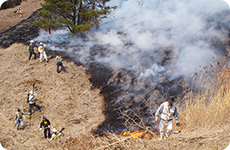
The highlands at the foothills of the mountains have been maintained by people living in the area for over a thousand years through agricultural activities such as growing crops, grazing cattle, and controlled burning.
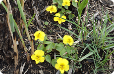
Along the trails themselves, visitors can enjoy various flowers, such as golden violets (Viola orientalis), purple fringed galax (Schizocodon soldanelloides), small white tsukushizeri (Angelica longeradiata), and many more, all of which are designated protected species by the park.
Please see the Aso-kuju National Park Flower Map for more information (in Japanese).
What to Bring
If you are new to hiking, you might feel a bit uncertain about what you need to enjoy Mt. Aso. We have made a list of recommended clothing and things to bring to get the most out of your visit.
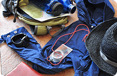
Clothing
Comfortable and quick-drying clothing
Rainwear
Hat
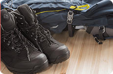
Hiking boots
We recommend wearing hiking boots, as most
of the hiking trails at Mt. Aso are covered with jagged igneous rock, which could tear
a hole in a pair of sneakers or other thin-soled shoes.
* The footpaths at Mt. Kishimadake are mostly paved roads, so sneakers are acceptable footwear.
Essential Items
Rucksack
Whistle
Cell phone
Garbage bag
Map
Portable toilet
Compass
Emergency items
Water bottle (and emergency water)
Emergency food, such as sweets or chocolate
Headlamp
Handy Items
Portable charger
Trekking poles
Insect repellent
Sunscreen
Equipment for Hiking an Active Volcano (Mt. Nakadake, Mt. Takadake)
Safety helmet and goggles
to protect your head and eyes from falling rocks and volcanic ash
A damp towel or handkerchief
to cover your mouth if you start to smell volcanic gas
Winter Equipment
During the winter months, visitors should come prepared for snow and icy conditions. Some of the essential equipment is listed below.
Waterproof outerwear (coat and pants)
Down jacket
Gloves, hat, scarf, etc.
Lightweight crampons or traction cleats, etc.
Trekking poles